Skip to content

Professional planning case study

Built to support the people responsible for the plan.

SighThor brings drone route visibility and terrain-aware camera coverage into one professional beta for drone pilots, camera installers, security consultants and organisations responsible for complex sites.

01 / The need

Professional teams need more than attractive geometry.

A useful planning workspace must explain which sources were used, where uncertainty remains, what the model found and which decisions still belong to accountable people.

Data

Source health that stays visible

Terrain, buildings, vegetation, airspace and weather retain their coverage, freshness and failure state instead of disappearing behind a clean result.

Calculation

One scene across every result

Camera, route, 3D and export paths stay bound to the same source evidence and calculation revision.

Experience

A clear next professional action

Readiness states distinguish what is complete, what needs attention and what blocks a reviewable draft.

02 / Method and architecture

Designed around accountable review from the start.

UK aviation requirements, terrain and LiDAR access, camera-design practice and source licensing inform an architecture built around frozen scenes and human-reviewed evidence.

Product position
Professional simulation and evidence acceleration — not an automatic permission service.
Data model
Preview, Enhanced and Verified grades remain separate from finding and report lifecycle states.
Calculation contract
One scene snapshot binds configuration, source evidence, engine version and deterministic outcome.
Failure contract
Unknown, partial, stale and failed evidence cannot silently become flat terrain or a clean result.
Review contract
Analysis remains a planning draft until competent human review; permission and authority outcomes stay external.
03 / Working evidence

See the site, the model and the remaining uncertainty.

Photographic scenarios show the operational context while the planning overlays make terrain, obstruction, overlap and areas requiring review visible.
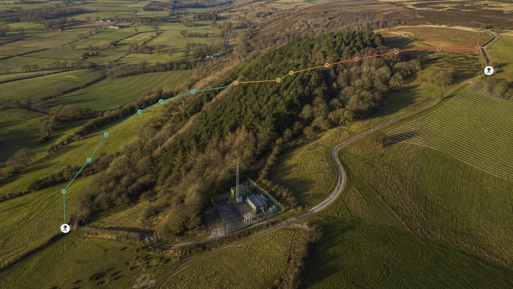
Oblique aerial view of a professional drone survey route crossing wooded terrain, with clear, warning and blocked route sections
Flight terrain proof

A route that shows where visibility confidence changes.

Terrain relief and changing route confidence remain visible in one professional planning view.
Route LOSTerrain reliefReview zones
Illustrative professional scenario — not an operational result or surveyed truth.
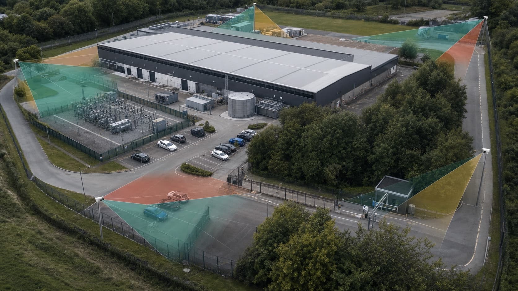
Oblique aerial view of a secured commercial site with professional camera coverage volumes clipped by buildings and trees
Camera coverage proof

Coverage shaped by the actual site, not a flat plan.

Buildings, perimeter geometry and vegetation visibly affect the model before a design is handed to a practitioner.

Scene obstructionCoverage overlapField review
Illustrative professional scenario — nominal coverage is not guaranteed field performance.
04 / Safety boundary

The work is strongest where it stays honest.

Wales Enhanced remains blocked pending authoritative datum evidence. Paid OSNI data remains disabled. Geometric VLOS and nominal DORI remain inputs to practitioner review, not automatic professional decisions.

Delivered capability

  • Server-side bounded terrain and surface evidence.
  • Deterministic camera and route analysis foundations.
  • Visible source health and immutable provenance.
  • Professional workflow and report-lifecycle architecture.
  • Anonymous frozen proof and public methodology.

Independent work still required

  • Aviation specialist review of UK rule packs and evidence wording.
  • CCTV practitioner comparison with measured field scenes.
  • Operational feedback from pilots, installers and consultants.
  • Source operations and licensing for each enabled deployment.
  • Expansion only after credible demand and validation.

For teams and organisations

Test the workflow against the planning work you actually do.

Create an account to try Camera Design or Flight Operations. Use the contact form to share feedback, describe a missing workflow or discuss a private deployment requirement without implying regulatory authority.